
If you’ve stepped outside these last couple of days, you’ve definitely noticed the cold hit way harder than you are used to. The temperatures have been dropping well below what feels normal for any other winter season, and snowfall has reached record level highs across the country. This unusually intense cold is part of a larger atmospheric event known as the 2026 Arctic Blast. The real cause of these cold temperatures lie far above the ground, in the upper layers of the atmosphere where major wind systems control how cold air moves around the planet.
The Polar Vortex: Normally a Containment System
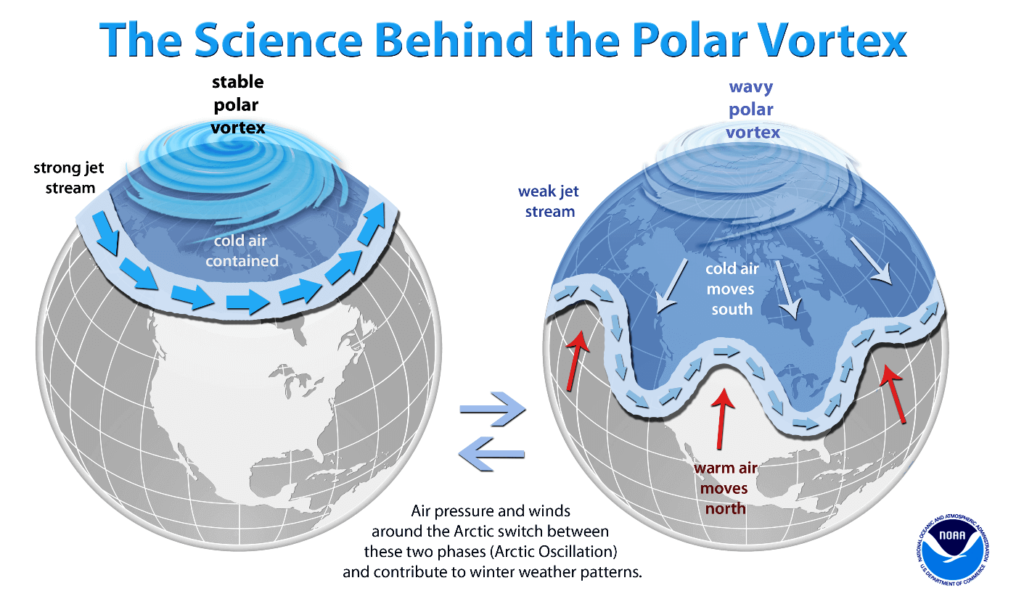
The polar vortex is a large band of winds that circles the Arctic every winter in the stratosphere, around 20 to 30 miles above Earth’s surface. Under normal conditions it acts like a barrier keeping the coldest Arctic air trapped near the North Pole.
During this winter season however, the system has weakened and stretched outward. When the polar vortex becomes distorted, it can no longer hold the cold air in place like it used to. As a result of this arctic air was able to spill southwards into the United States, causing temperatures far below the seasonal averages that we are used to.
What Caused the Breakdown
One of the main triggers behind this disruption was a sudden stratospheric warming (SSW) event. These events occur when large atmospheric waves force warm air into the stratosphere, rapidly increasing temperatures over the Arctic. This sudden warming weakens the polar vortex by disrupting the pressure and temperature balance that keeps it stable. In some cases, the vortex can even split or move away from the pole. Once that happens, the cold air it once contained is free to move south, setting the stage for the extreme winter weather weeks later.
Jet Stream’s Role in Prolonged Cold
The jetstream is a fast moving current of air much lower in the atmosphere that determines where cold and warm air masses travel. During this recent Arctic blast, the jet stream became unusually wavy and slow moving. These large curves allowed for the cold Arctic air to plunge into the continental U.S. while also blocking warmer air from returning north. This is the exact reason why the cold didn’t simply pass through in a couple days but instead settled in for the last few weeks.
Long Term Climate Influence
Warming in the Arctic is likely the leading cause of events such as this. The Arctic is warming faster than the rest of the planet, due to a mix of both natural and man made causes. As sea ice melts, the temperature difference between the Arctic and the mid-latitudes weakens, which is what causes the jet stream to become more unstable and prone to large swings.
Scientists are continuing to study the exact connection that is causing this phenomenon but with global warming we are likely to see even more polar vortex disruptions as the years continue. This weather phenomenon shows that global warming doesn’t necessarily mean winters stop being cold but instead it can lead to extremely erratic weather patterns. The weather is becoming less predictable and much more intense.
The cold that we have all been feeling is proof of how interconnected Earth’s systems are. Events unfolding high above the Arctic can directly shape the weather outside your front door. As weather patterns continue to change, understanding these systems will be critical to uncovering what the next steps humanity has got to take to prepare, adapt and protect ourselves from these extreme weather conditions.